![](/images/other/stat-length.png)
![Excursión Moto La Tieule - Balade Les Motards du Viaduc 2019 - Photo](https://media.geolcdn.com/t/1900/400/ext.pjpeg?maxdim=2&url=https%3A%2F%2Fstatic1.geolcdn.com%2Fsiteimages%2Fupload%2Ffiles%2F1524743155moto.jpg)
Balade Les Motards du Viaduc 2019
adsp63
Usuario
![Longitud](/images/other/stat-length.png)
Longitud
200 km
![Altitud máxima](https://static1.geolcdn.com/siteimages/upload/files/1508320355ic_sort_altitude_max_24dp.png)
Altitud máxima
1015 m
![Desnivel positivo](https://static1.geolcdn.com/siteimages/upload/files/1508320355ic_sort_den_pos_24dp.png)
Desnivel positivo
3444 m
![Km-Effort](/images/other/stat-length.png)
Km-Effort
246 km
![Altitud mínima](https://static1.geolcdn.com/siteimages/upload/files/1508320355ic_sort_altitude_min_24dp.png)
Altitud mínima
384 m
![Desnivel negativo](https://static1.geolcdn.com/siteimages/upload/files/1508320355ic_sort_den_neg_24dp.png)
Desnivel negativo
3579 m
![Boucle](https://static1.geolcdn.com/siteimages/upload/files/16400158638029165_repeat_loop_refresh_sync_direction_icon.png)
Boucle
No
Fecha de creación :
2019-07-06 12:40:00.233
Última modificación :
2019-07-08 12:05:07.693
![Moto](https://static1.geolcdn.com/sitytour/trail-icons/402.png)
2h27
Dificultad : Muy fácil
![Escanee este código QR para abrir la excursión en la aplicación SityTrail](https://capi.geolives.com/qq0zvz2zws4bq2lad0pu/sitytour/trails/2132781/qr.png?size=200)
Aplicación GPS de excursión GRATIS
A propósito
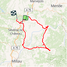
Ruta Moto de 200 km a descubrir en Occitania, Lozère, La Tieule. Esta ruta ha sido propuesta por adsp63.
Descripción
Balade magnifique faite en moto lors du rassemblement annuel 2019 des Motards du Viaduc "ensemble contre la mucoviscidose".
Localización
País:
France
Región :
Occitania
Departamento/provincia :
Lozère
Municipio :
La Tieule
Localidad:
Unknown
Salida:(Dec)
Salida:(UTM)
511031 ; 4914356 (31T) N.
Comentarios
Excursiones cerca
![Excursión Senderismo Campagnac - tour du causse - Photo](https://media.geolcdn.com/t/375/260/ext.jpg?maxdim=2&url=https%3A%2F%2Fstatic1.geolcdn.com%2Fsiteimages%2Fupload%2Ffiles%2F1553511878bg_sport_marche.png)
![Senderismo Senderismo](https://static1.geolcdn.com/sitytour/trail-icons/101.png)
tour du causse
Senderismo
Muy fácil
(1)
Campagnac,
Occitania,
Aveyron,
France
![](/images/other/stat-length.png)
8,3 km | 11,2 km-effort
2h 0min
![](https://static1.geolcdn.com/siteimages/upload/files/16400158638029165_repeat_loop_refresh_sync_direction_icon.png)
Sí
![Excursión Paseo ecuestre La Tieule - La Tieule - Etoile par Le Maynard - Photo](https://media.geolcdn.com/t/375/260/ext.jpg?maxdim=2&url=https%3A%2F%2Fstatic1.geolcdn.com%2Fsiteimages%2Fupload%2Ffiles%2F1524743154cheval.jpg)
![Paseo ecuestre Paseo ecuestre](https://static1.geolcdn.com/sitytour/trail-icons/301.png)
La Tieule - Etoile par Le Maynard
Paseo ecuestre
Difícil
La Tieule,
Occitania,
Lozère,
France
![](/images/other/stat-length.png)
27 km | 37 km-effort
4h 53min
![](https://static1.geolcdn.com/siteimages/upload/files/16400158638029165_repeat_loop_refresh_sync_direction_icon.png)
Sí
![Excursión Paseo ecuestre La Tieule - Etoile La Tieule par Rouge Parets - Photo](https://media.geolcdn.com/t/375/260/ext.jpg?maxdim=2&url=https%3A%2F%2Fstatic1.geolcdn.com%2Fsiteimages%2Fupload%2Ffiles%2F1524743154cheval.jpg)
![Paseo ecuestre Paseo ecuestre](https://static1.geolcdn.com/sitytour/trail-icons/301.png)
Etoile La Tieule par Rouge Parets
Paseo ecuestre
Difícil
La Tieule,
Occitania,
Lozère,
France
![](/images/other/stat-length.png)
26 km | 36 km-effort
4h 45min
![](https://static1.geolcdn.com/siteimages/upload/files/16400158638029165_repeat_loop_refresh_sync_direction_icon.png)
Sí
![Excursión Paseo ecuestre La Tieule - Etoile de Coustaraços ( La Tieule par Meynard et Pertuzades) - Photo](https://media.geolcdn.com/t/375/260/ext.jpg?maxdim=2&url=https%3A%2F%2Fstatic1.geolcdn.com%2Fsiteimages%2Fupload%2Ffiles%2F1524743154cheval.jpg)
![Paseo ecuestre Paseo ecuestre](https://static1.geolcdn.com/sitytour/trail-icons/301.png)
Etoile de Coustaraços ( La Tieule par Meynard et Pertuzades)
Paseo ecuestre
Muy difícil
La Tieule,
Occitania,
Lozère,
France
![](/images/other/stat-length.png)
29 km | 42 km-effort
5h 33min
![](https://static1.geolcdn.com/siteimages/upload/files/16400158638029165_repeat_loop_refresh_sync_direction_icon.png)
Sí
![Excursión Senderismo La Tieule - Chemin de St Guilhem - La Tieule - Saint Georges de Lévéjac - Photo](https://media.geolcdn.com/t/375/260/ext.jpg?maxdim=2&url=https%3A%2F%2Fstatic1.geolcdn.com%2Fsiteimages%2Fupload%2Ffiles%2F1553511878bg_sport_marche.png)
![Senderismo Senderismo](https://static1.geolcdn.com/sitytour/trail-icons/101.png)
Chemin de St Guilhem - La Tieule - Saint Georges de Lévéjac
Senderismo
Muy difícil
La Tieule,
Occitania,
Lozère,
France
![](/images/other/stat-length.png)
21 km | 28 km-effort
5h 56min
![](https://static1.geolcdn.com/siteimages/upload/files/16400158638029165_repeat_loop_refresh_sync_direction_icon.png)
No
![Excursión Paseo ecuestre La Tieule - Grande Boucle Tieule/Canourgue/Champerboux/StEnimie/MasRouch/Tieule - Photo](https://media.geolcdn.com/t/375/260/ext.jpg?maxdim=2&url=https%3A%2F%2Fstatic1.geolcdn.com%2Fsiteimages%2Fupload%2Ffiles%2F1524743154cheval.jpg)
![Paseo ecuestre Paseo ecuestre](https://static1.geolcdn.com/sitytour/trail-icons/301.png)
Grande Boucle Tieule/Canourgue/Champerboux/StEnimie/MasRouch/Tieule
Paseo ecuestre
Muy difícil
La Tieule,
Occitania,
Lozère,
France
![](/images/other/stat-length.png)
91 km | 123 km-effort
15h 4min
![](https://static1.geolcdn.com/siteimages/upload/files/16400158638029165_repeat_loop_refresh_sync_direction_icon.png)
Sí
![Excursión Paseo ecuestre La Tieule - Boucle La Canourgue/ La Tieule / Mas Rouch - Photo](https://media.geolcdn.com/t/375/260/ext.jpg?maxdim=2&url=https%3A%2F%2Fstatic1.geolcdn.com%2Fsiteimages%2Fupload%2Ffiles%2F1524743154cheval.jpg)
![Paseo ecuestre Paseo ecuestre](https://static1.geolcdn.com/sitytour/trail-icons/301.png)
Boucle La Canourgue/ La Tieule / Mas Rouch
Paseo ecuestre
Muy fácil
La Tieule,
Occitania,
Lozère,
France
![](/images/other/stat-length.png)
66 km | 91 km-effort
Desconocido
![](https://static1.geolcdn.com/siteimages/upload/files/16400158638029165_repeat_loop_refresh_sync_direction_icon.png)
Sí
![Excursión Senderismo Campagnac - Campagnac - Photo](https://media.geolcdn.com/t/375/260/ext.jpg?maxdim=2&url=https%3A%2F%2Fstatic1.geolcdn.com%2Fsiteimages%2Fupload%2Ffiles%2F1553511878bg_sport_marche.png)
![Senderismo Senderismo](https://static1.geolcdn.com/sitytour/trail-icons/101.png)
Campagnac
Senderismo
Muy fácil
Campagnac,
Occitania,
Aveyron,
France
![](/images/other/stat-length.png)
14 km | 17,9 km-effort
5h 52min
![](https://static1.geolcdn.com/siteimages/upload/files/16400158638029165_repeat_loop_refresh_sync_direction_icon.png)
Sí
![Excursión Senderismo Campagnac - La Maison du Peintre - Photo](https://media.geolcdn.com/t/375/260/ext.jpg?maxdim=2&url=https%3A%2F%2Fstatic1.geolcdn.com%2Fsiteimages%2Fupload%2Ffiles%2F1553511878bg_sport_marche.png)
![Senderismo Senderismo](https://static1.geolcdn.com/sitytour/trail-icons/101.png)
La Maison du Peintre
Senderismo
Fácil
Campagnac,
Occitania,
Aveyron,
France
![](/images/other/stat-length.png)
6 km | 8,1 km-effort
1h 45min
![](https://static1.geolcdn.com/siteimages/upload/files/16400158638029165_repeat_loop_refresh_sync_direction_icon.png)
Sí